U.S. migrations are sketchy at best and complex in general.
http://www.fhwa.dot.gov/infrastructure/history.cfm
The above link is a set of stories that will guide you through migratory channels of the United States. There are many stories here to assist in your Genealogy research of U.S. migratory routes.
Example: http://www.fhwa.dot.gov/infrastructure/back0204.cfm
Back in Time
The Cumberland Gap
By Rickie Longfellow
The Cumberland Gap, which measures 1,304 feet in altitude, is Nature's passage through the Cumberland Mountains between Kentucky, Tennessee and Virginia. One of three natural breaks in the rugged Appalachian Mountain range, it served as a gateway in prehistoric times, when Native Americans used it as a footpath and buffalo used it to seek greener pastures.
In 1750, Dr. Thomas Walker, an English naturalist and scientist, led a small party of explorers to the Gap after hearing Native American descriptions of the pathway through, rather than over the mountains. Walker called it the Cave Gap, and named the river north of the pass the Cumberland River, after the Duke of Cumberland, son of Britain's King George II, who funded Walker and his group. In 1769, Daniel Boone explored the area and in 1775 he blazed the 200-mile trail known as Boone's Path or Boone's Road. The trail, beginning at the Gap, passed through Virginia to Kentucky's Bluegrass Region.
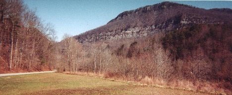 View of Cumberland Gap from the east. Photo from the Wilderness Road Company Web Site. |
If the journey was not treacherous enough, there was also the occasional massacre by renegade natives. During the summer and fall of 1784, more than 100 travelers were killed on the Kentucky side of the gap. Like the ill-fated Donner Party, travelers had to abandon wagons full of household necessities in bad weather to travel the narrow gap by foot or horse. By 1796 it was known as the Wilderness Road having seen as many as 200,000 travelers, including Abraham Lincoln's parents and grandparents as they emigrated west. The Gap was then widened to allow Conestoga Wagons through to lands west.The Gap was used for commerce by 1800. Kentuckians drove long lines of horses and cattle through the Gap to the markets in the east. But by the 1830s, other east/west routes had been established, including the National Road, causing the Gap's popularity to decline.
During the Civil War both North and South held the Gap, prepared for an invasion that never happened. Both sides cleared and chopped the terrain. On September 9, 1863 a soldier from the 125th Ohio, O.G. Swingburg, wrote, "The trees, which had formerly covered the mountains were all cut down. Their trunks lie tangled and scattered in all directions to prevent rapid charges of infantry. Surely, a valley of death could not have been more skillfully constructed. All who walked that road today would agree that had the charge been made, it would have been the last road walked in eternity. It would have been murder to have ordered that assault." In 1866, the Federal Army abandoned the road after exchanging it several times with the Confederacy.
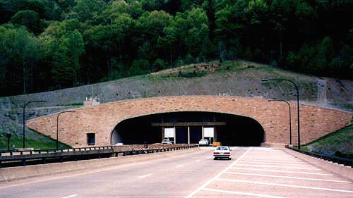 The Cumberland Gap Tunnel. This is the Tennessee portal where you can see the viaduct approach to the tunnel. Photo by H.B. Elkins. Photo from the Cumberland Gap Tunnel Web Site |
Then the railroads came, but they bypassed the Gap after the Civil War, further easing east /west travel. The arrival of the automobile rekindled interest in using the Gap again. In 1908, the U.S. government built a "macadamized" road (layers of compacted broken stone) connecting Middlesboro, Kentucky to Cumberland Gap, Tennessee, and called it the Government Pike. The new road passed by Soldier's Cave, which became a tourist attraction, bringing more automobiles to the area. In 1916, Virginia, Kentucky and Tennessee built a similar road connecting the Government Pike to the "Dixie Highway" system.
In 1920, Lincoln Memorial University bought the Gap and tourist attraction "Cudjo's Cave" and surrounding land. In 1925, the Gap was included in the planning of U.S. Highways, on U.S. 411's planned route from Bristol, Virginia, to Corbin, Kentucky. The Tennessee approach was not included, as it had been in the Dixie Highway. U.S. 25 had been assigned to much of the Dixie Highway. By 1926, U.S. 25 was split with an eastern leg passing through the Cumberland Gap. U.S. 58 replaced U.S. 411 in 1934.
In the 1940's, The Cumberland Gap National Historic Park was established to protect and control the 20,000 acres of forested mountain. The tourism of the Cave was booming and with electricity installed, accommodations for overnight lodging was provided. Tennessee shares Cumberland Gap National Historic Park with Kentucky and Virginia, where the famous mountain pass lies.
In the 1990s, the Cumberland Gap Tunnel, a four-lane twin-bore mountain tunnel 4,600 feet long, was built under the mountain to replace the dangerous Gap road. The Federal Highway Administration's Eastern Federal Lands Highway Division administered the tunnel project for the National Park Service. The tab was $280 million, more than twice the estimate, since the old mountain had some surprises for the engineers-a system of underground streams.
The old Gap road was closed, with an estimated 5 deaths per year attributed to it. The Federal Highway Administration spent about $5 million to remove all traces of the old road on the Kentucky-Virginia border and to restore the land to its original beauty. Talented work crews using descriptions from old journals and maps have recreated the terrain to the appearance Daniel Boone first saw. The Cumberland Gap has come full circle through time-the man-made road is gone and the ancient trails returned.